 https://lapisit.com.au/wp-content/uploads/2024/08/Lapis-HC-Blog-post-snippet.png
1920
1920
Hana Rellosa
https://lapisit.com.au/wp-content/uploads/2021/08/LapisLogo-Header-300x138.png
Hana Rellosa2024-08-02 10:10:282024-08-21 18:12:48Health Check Blog
https://lapisit.com.au/wp-content/uploads/2024/08/Lapis-HC-Blog-post-snippet.png
1920
1920
Hana Rellosa
https://lapisit.com.au/wp-content/uploads/2021/08/LapisLogo-Header-300x138.png
Hana Rellosa2024-08-02 10:10:282024-08-21 18:12:48Health Check BlogThe Challenge
One platform, many users
The Department of Environment, Land, Water and Planning (DELWP) are responsible for creating thriving environments and communities. DELWP focuses on creating a community centric, liveable, inclusive and sustainable Victoria with thriving natural environments.
DELWP has a number of stakeholders with differing requirements that require access to over 10,000 topographic maps across Victoria.
The maps support a variety of activities including; emergency management planning and response, flora and fauna surveys, public land management, and recreational activities such as; four wheel driving, cycling, and bushwalking.
Lapis was tasked with providing an up-to-date, robust and effective system to meet a complex brief including;
- Enabling users to easily interact with government services and information
- Bringing together the physical assets and different systems into an integrated interface
- Ensuring the information was accurate, useful and always available
- Incorporating a secure payment gateway
- Protecting sensitive user data, information and identities
- Meeting the needs of commercial, government and community users
- Incorporating a secure payment gateway & protecting user information and identities
- Supporting community users to access the information for recreational uses
- Enabling fact based decision making and operational efficiency and effectiveness for commercial and
- government users who require the assets for commercial and compliance purposes
Need a system for your organisation?
The Approach
Understanding different user requirements and abilities
Lapis followed a proven approach to engage with the DELWP to scope the detailed requirements for the project to ensure that critical project outcomes were delivered.
This included developing an understanding of the different use cases across each of the user groups as well as the; requirements, current pain points, ideal outcomes, and differing levels of sophistication of the individual users.
“Lapis were able to deliver an innovative spatial solution that met the specialist needs of various government and non government users, leveraging off the functionality they built with the successful Vicmap Viewer. Vicmap Topographic Mapping Online, alongside Vicmap Viewer, now provides a powerful mapping tool to help facilitate decision making across all user sectors.”
George Mifsud, Team Leader, Vicmap Foundation Mapping,
Vicmap Data Services at DELWP – Local Infrastructure – Land Use Victoria
Importantly, this approach enabled us to develop a tool and an interface that supported users with more complex commercial or compliance requirements as well those with a recreational mindset while meeting the overall brief provided by DELWP.
Working closely with Land Use Victoria as the project owner, Lapis developed a framework model for approval and then undertook the build of the solution applying an agile methodology. This ensured the highest possible functionality within the parameters set by the client requirements, the budget, the user types and the information to be incorporated.
The Results
Seamless map access for all
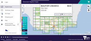
The web-based mapping app provides users with an easy and efficient method of discovering and accessing accurate topographic mapping. The solution was developed to enable Victorians to transact with government services and information in a way that is useful, easy and always available.
The app provides users with access to over 10,000 topographic maps across Victoria and is available to the whole of the Victorian Community, supporting a variety of commercial, compliance, government and recreational activities and uses.
Vicmap Topographic Maps Online has streamlined the cumbersome process of accessing mapping products and services from third-party online portals and then having to transfer them to mobile devices. The web app provides an ability to create custom topographic maps in an easy and intuitive way. The app has a simple shopping cart and links to a payment gateway for users to pay for their selected maps and be able to download them.


