 https://lapisit.com.au/wp-content/uploads/2024/08/Lapis-HC-Blog-post-snippet.png
1920
1920
Hana Rellosa
https://lapisit.com.au/wp-content/uploads/2021/08/LapisLogo-Header-300x138.png
Hana Rellosa2024-08-02 10:10:282024-08-21 18:12:48Health Check Blog
https://lapisit.com.au/wp-content/uploads/2024/08/Lapis-HC-Blog-post-snippet.png
1920
1920
Hana Rellosa
https://lapisit.com.au/wp-content/uploads/2021/08/LapisLogo-Header-300x138.png
Hana Rellosa2024-08-02 10:10:282024-08-21 18:12:48Health Check BlogThe Challenge
From manual to digital
Melbourne Water’s Frog Census program was established in 2001 centred around community data capture to assist in mapping Melbourne’s frog populations. Previously, volunteers recorded frogs at their local waterway or wetland using various audio recording devices and then sent them to Melbourne Water via email. These submissions were then independently verified by consultants.
The use of old devices for recording audio and creating reports of these sightings to be submitted via email created a barrier for new volunteers. After a survey of participants, it was clear to Melbourne Water that the participants would like an easier process of submitting reports, better feedback on results and a mobile app.
Melbourne Water’s priority was to attract new volunteers to their program, increase the number of submitted reports, reduce staff time and provide frog knowledge as an educational tool to the community.
Lapis were tasked with creating an application that would work across all devices with a robust offline mode that ensured the user’s functionality didn’t deteriorate in rural areas. The app needed to integrate an admin portal for expert review of submitted reports, creating a seamless digital ecosystem.
Need a human-centric business app?
The Approach
Fit for casual and professional use
Great care was taken to ensure an intuitive data collection process for even a casual nature-goer. Lapis engaged in close consultation with Melbourne Water to understand different user needs and abilities, ensuring this requirement was fulfilled.
Lapis applied its thorough agile design and development process to incorporate a powerful suite of features to provide the greatest value for communal research.
“With the launch of the app, we’re making it even easier for the community to be part of the important work we do monitoring Melbourne’s frog populations. Every record helps improve conservation efforts.”
—Richard Akers, Waterwatch Coordinator, Melbourne Water
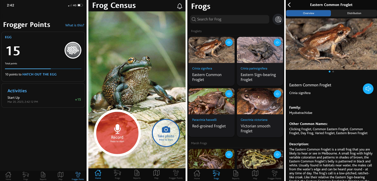
The app includes robust data recording features, allowing users to record not only the location of frogs within the Melbourne region, but also audio recordings of the frog callings and other useful information. This information is then made available to the public, benefiting management authorities, researchers, the Melbourne Water Frog Census program and students.
Lapis’ solution is a fully flexible, responsive mobile application that features a robust offline mode that ensured the user’s functionality didn’t deteriorate when they were in rural areas.
Updates
The initiative continues to intrigue more than just frog fanatics. Science students and primary schoolers are another captive audience of this charming learning experience. A recent addition to the app enables kids (of all ages) to earn ‘frogger points’ to go towards achievement badges and resource rewards based on the number and quality of their reports.
With a frog informed public on board, management authorities, researchers and the Melbourne Water Frog Census program all benefit. An admin portal for expert review of submissions facilitates a quicker and cheaper way to verify frog reports and provide feedback to volunteers. When reports are verified they appear on a public map within the app. This data is also used in waterway management and shared with the Victorian Biodiversity Atlas and CSIRO Atlas of Living Australia.
In addition, a robust offline mode for both Android and iOS ensure the functionality holds up in rural areas. Similar to the Lapis developed WhaleReport app, reports – including audio and photos – can be saved and sent when internet connection is restored. The app even features weather data tagging using client location, time of submission and the nearest Bureau of Meteorology data.
The engaging downloadable encyclopedia features 16 local frog species, each with a call recording, description, habitat, distribution map and photo to assist users. A series of ’Frogging 101’ Youtube videos supports the app by providing useful planning, search, conservation and recording tips.
With a frog informed public on board, management authorities, researchers and the Melbourne Water Frog Census program all benefit. An admin portal for expert review of submissions facilitates a quicker and cheaper way to verify frog reports and provide feedback to volunteers. When reports are verified they appear on a public map within the app. This data is also used in waterway management and shared with the Victorian Biodiversity Atlas and CSIRO Atlas of Living Australia.
In addition, a robust offline mode for both Android and iOS ensure the functionality holds up in rural areas. Similar to the Lapis developed WhaleReport app, reports – including audio and photos – can be saved and sent when internet connection is restored. The app even features weather data tagging using client location, time of submission and the nearest Bureau of Meteorology data.
The Results
An 85% increase in volunteer participation
The app received phenomenal uptake from the community, reaching 1000 recordings just 8 months after its launch. In the year prior to the app launch, Melbourne Water received 249 reports for the whole year, marking a substantial increase since the app was introduced. In addition, the app saw an 85% increase in volunteers participating in the program, as well as a 4.46 average user rating through in-app feedback, reflecting the app’s strong usability.
The Frog Census app:
- Assists in the creation of a robust database of reported and verified frogs that will assist Melbourne Water with their waterway management
- Offers powerful updating functionality, allowing Melbourne Water to push new data to the application as needed
- Contains an admin portal for expert review of submitted reports, making it quicker and cheaper to verify the frog report and provide feedback to the volunteers
- Works offline on both Android and iOS which recognises the inconsistent reception available in parts of rural Victoria
- Contains an engaging encyclopedia of local frog species complete with attractive photos and audio of each frog
- Integrates weather data tagging using client location, time of submission and the closest Bureau of Meteorology (BOM) weather stations data
