 https://lapisit.com.au/wp-content/uploads/2024/08/Lapis-HC-Blog-post-snippet.png
1920
1920
Hana Rellosa
https://lapisit.com.au/wp-content/uploads/2021/08/LapisLogo-Header-300x138.png
Hana Rellosa2024-08-02 10:10:282024-08-21 18:12:48Health Check Blog
https://lapisit.com.au/wp-content/uploads/2024/08/Lapis-HC-Blog-post-snippet.png
1920
1920
Hana Rellosa
https://lapisit.com.au/wp-content/uploads/2021/08/LapisLogo-Header-300x138.png
Hana Rellosa2024-08-02 10:10:282024-08-21 18:12:48Health Check BlogThe Challenge
An efficient, consistent resource
Bushfire is a present danger and constant risk in local communities. Bushfire prevention and preparation is an important part of the NSW Rural Fire Service (NSW RFS) response to the threat of bushfires.
The agency’s document titled “Bushfire Protection for Existing Development Guideline” sets out a process for the assessment and treatment of bushfire hazards at a property level.
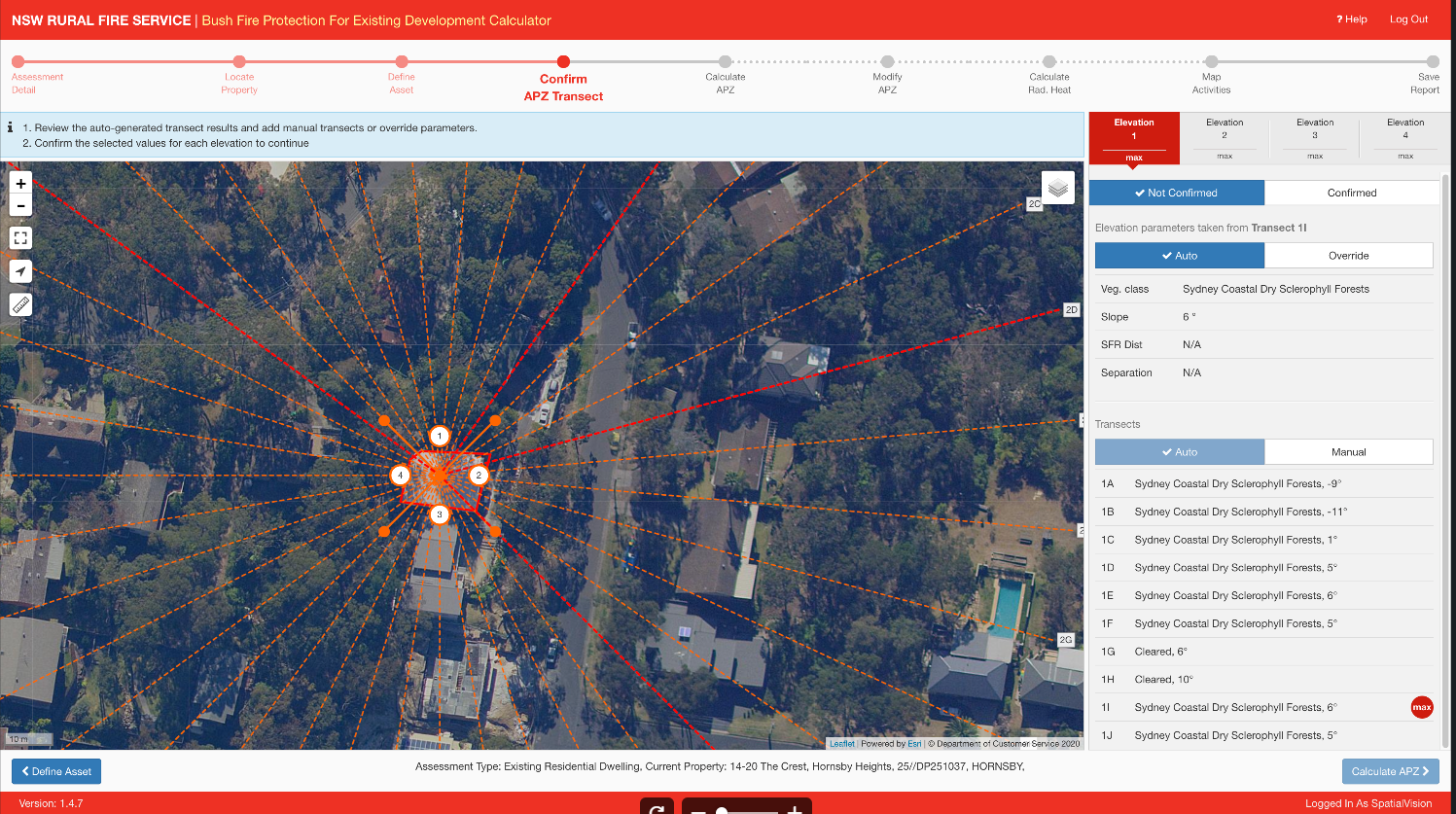
To support the application of the Guideline, the NSW RFS commissioned Lapis to develop an online tool that allows their staff and other agencies to assess bushfire risk and determine the required treatments for a given property.
The brief to Lapis was to provide an online tool that reflected the guidelines in an easy to use interactive tool to improve the efficiency and accuracy (consistency) of the application of the guide.
Digitising the guide means that in the unfortunate event of a bushfire, the community has been better protected against the threat. This mitigates property risk, allows time for proper preparation, and most importantly helps protect the lives of people.
Need to bring together complex data?
The Approach
Ensuring engagement and compliance
In order to best respond to the brief, Lapis invested time in understanding both the information contained in the guidelines and the key behavioural drivers that would ensure engagement and compliance from field staff to improve efficiency and consistency.
Working collaboratively with the NSW RFS team, we developed the framework for the system and identified the key engagement points and steps that would be critical in digitising the guide for use in the field by NSW RFS staff and other agencies.
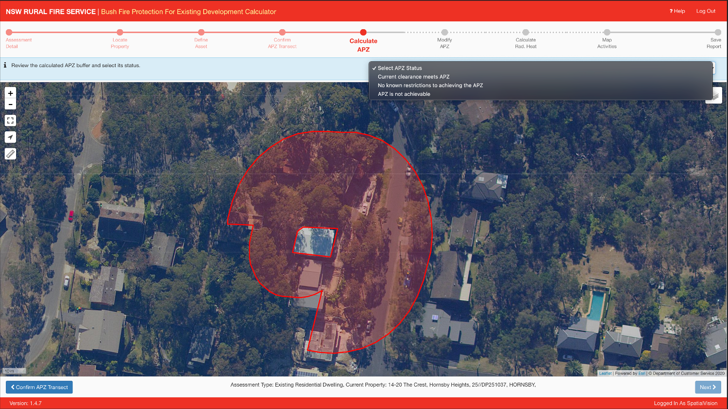
The tool comprises three components, an easy to use map-based web interface which is mobile and touch friendly, a set of geo-processing services which provide critical map data such as slope and vegetation and create buffer polygons and map reports and a calculator service which implements the complex radiant heat calculations.
The web site was developed using a range of ESRI technologies including ArcGIS Server map and geo-processing services, with the web interface developed with the open source Leaflet mapping framework. The BPED tool is also integrated with the aspatial RFS Guardian system via a set of custom web services that write spatial features into a shared spatial data repository.
Lapis also developed a set of reporting tools for NSW RFS to provide important insights.
The Results
Accessible and digestible information
Lapis successfully delivered the app and system to NSW RFS and it has been deployed in rural communities with a very positive response from NSW RFS staff and other agencies.
Applying our skills and an agile development approach we successfully digitised the guide and provided a platform that NSW RFS could use to effectively disseminate the guidelines in an accessible and digestible format across their own field staff and other agencies.
- This tool helps RFS officers to assess the risk of fire hazard for a property based on different factors using an innovative map based interface.
- The tool does not make decisions but rather, it provides data that can be used to follow the guidelines to decrease the risk of a fire for a given property
- The tool can be used on the desktop or in-field using iPAD or Android Tablet
- The tool uses the latest Java Script based technologies and plugins to create an intuitive user interface for a complex business process.
- The tool makes it easy for the FRS offices to access the fire risk for a property and take concrete actions to reduce the risk based on guidelines. This way if there are any actions to be taken to mitigate the risk the tool will suggest and officers can judge how much of the activities can be undertaken.


