 https://lapisit.com.au/wp-content/uploads/2024/08/Lapis-HC-Blog-post-snippet.png
1920
1920
Hana Rellosa
https://lapisit.com.au/wp-content/uploads/2021/08/LapisLogo-Header-300x138.png
Hana Rellosa2024-08-02 10:10:282024-08-21 18:12:48Health Check Blog
https://lapisit.com.au/wp-content/uploads/2024/08/Lapis-HC-Blog-post-snippet.png
1920
1920
Hana Rellosa
https://lapisit.com.au/wp-content/uploads/2021/08/LapisLogo-Header-300x138.png
Hana Rellosa2024-08-02 10:10:282024-08-21 18:12:48Health Check BlogThe Challenge
Informing community, commercial and government stakeholders
Australia’s national environmental law, the Environmental Protection and Biodiversity Conservation Act 1999 (the EPBC Act) protects nationally significant animals, plants, habitats and places. These are covered under 9 categories including national heritage sites and properties through to habitats for protected species.
Before any changes in land use or new developments can be approved, any potential negative impacts on matters of national significance must be carefully considered.
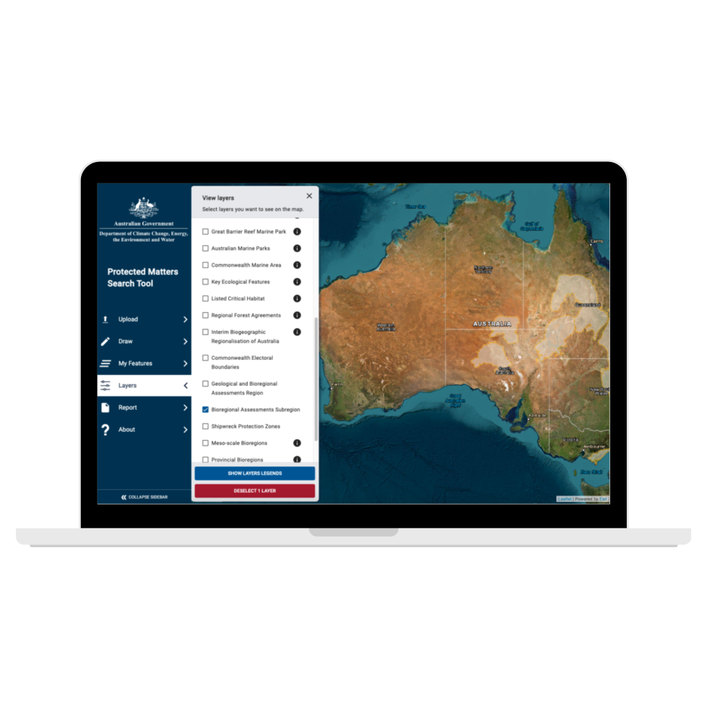
Lapis was engaged by the Department of Water Agriculture & Environment as experts in modern geospatial user interfaces to re-develop the existing Protected Matters Search Tool (PMST) using the latest technologies and create a modern, intuitive user interface.
The Department set a brief for Lapis that included several key elements, including:
- The legal requirement and obligations under the Act to accurately identify sites and convey that critical information to stakeholders
- The challenge of bringing together disparate data sources and databases
- The requirement to deliver a modern intuitive user interface
- The need for accuracy in identifying and mapping the location of protected matters and communicating these to stakeholders in real time and on demand
- Dealing with a complicated data-set and an outdated legacy system
- Working collaboratively with the internal IT department and other IT providers
- The complexity and variety of the sites and protected matter types
- Delivering a robust solution that addressed the needs of the department and the key government, community and commercial stakeholders
Diagnose your digital risks and opportunities with a Health Check.
The Approach
Collaborative co-design
Partnering with ThinkPlace, Lapis worked collaboratively on the design phase with the Department’s technical team to understand stakeholder needs and requirements.
Through an agile approach, the Lapis team led the software development phase, leveraging extensive experience in spatial web app development and location-based IT solutions.
“We had a great partnership with [Lapis and Think Place] and their dedication to the website that they developed for the Department’s stakeholders is evident. We appreciate their responsiveness and accommodating approach to bring the Protected Matter Search Tool online using contemporary web design and technology.”
Director (Acting), Spatial Enablement, Department of Agriculture, Water and Environment
Lapis successfully brought together and integrated data sources and outputs and dealt with a complex framework covering the nine matters of national significance set out in the Act; world heritage properties, national heritage places, wetlands of international importance, listed threatened species and ecological communities, migratory species protected under international agreements, Commonwealth marine areas, Great Barrier Reef Marine Park, nuclear actions & uranium mines, a water resource, in relation to coal seam gas development and large coal mining development.
The Results
A practical and powerful solution
Lapis has assisted the department to provide a practical and powerful interface that enables users to; access critically important information, identify potential impacts from their activities, and take appropriate action to meet their legal obligations to protect nationally significant animals, plants, habitats and places.
The new and improved tool provides a modern, user-friendly interface with added functionality including advanced search and dynamic reporting capabilities.
The latest technologies underpin the solution with a robust front-end framework Angular providing enhanced speed and performance for users including:
- Sleek, modern and initiative user interface making it easy for stakeholders of development projects to access the matters of national significance in their areas of interest
- Advanced mapping features that enable the users to create their area of interest via various methods – uploading the spatial files or drawing on the map
- A workbench capability to manage multiple areas of interest for reporting and able to navigate between them with ease
- Ability to generate PDF/CSV reports based on area of interest and download them
- Advanced search that enables the user to search for properties, communities/species and regions


